Randonnée Marche The Borough District of Drogheda - 2010-11-23 - 20h31m45 - Photo
 RVCrazy
RVCrazy

Utilisateur

© OpenStreetMap contributors
Longueur
Longueur
5,9 km
Altitude max
Altitude max
35 m
Dénivelé positif
Dénivelé positif
54 m
Km-Effort
Km-Effort  
6,7 km
Altitude min
Altitude min
3 m
Dénivelé négatif
Dénivelé négatif
55 m
Boucle
Boucle
Oui
Date de création :
2014-12-10 00:00:00.0
Dernière modification :
2014-12-10 00:00:00.0

(0 Avis)

Marche
Marche
--
Difficulté : Inconnu

Scannez ce code QR pour ouvrir la randonnée dans l'application SityTrail

Application GPS de randonnée GRATUITE

Logo SityTrail SityTrail

IGN / Instituts géographiques

Télécharger SityTrail sur l'App Store Télécharger SityTrail sur Google Play

Logo SityTrail SityTrail World

Le monde est à vous

Télécharger SityTrail sur l'App Store Télécharger SityTrail sur Google Play Télécharger SityTrail sur Huawei AppGallery

À propos

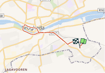
Randonnée Marche de 5,9 km à découvrir à Inconnu, County Louth, The Borough District of Drogheda. Cette randonnée est proposée par RVCrazy.

Profil altimétrique

Photos

Points d'intérêt

Point d'intérêt The Borough District of Drogheda - ashdale - Photo
RVCrazy
THE BOROUGH DISTRICT OF DROGHEDA 

Localisation

Pays :
Irlande
Région :
Inconnu
Département/Province :
County Louth
Commune :
The Borough District of Drogheda
Localité :
St. Mary's
Départ:(Dec)
Départ:(UTM)
676557 ; 5954365 (29U) N.

Randonnées à proximité


Fermer
Mes abonnements